
AltPalanka – Alt-Palanka (German) – Ó-Palánka (Hungarian) – Banatska Palanka, Serbia (Official)
South Banat District Vojvodina – NE District of Serbia
Located in the Bela Crkva municipality, South Banat District of Vojvodina.
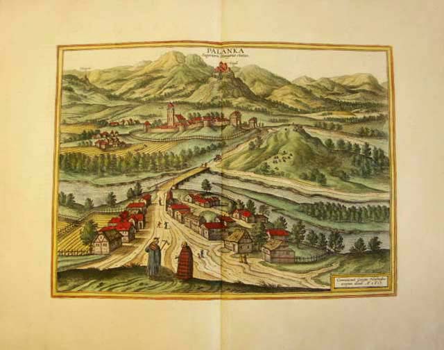
MAP DESCRIPTION: The excellent coloured engraving shows the city of Palanka in Hungaria. Banatska Palanka is a village in Serbia. It is situated in the Bela Crkva municipality, South Banat District, Vojvodina province. On the back you can find a latin description.
This wonderful view was published in the Janssonius town books in 1650. The town books contain views of cities and towns from all over the world and were published at a time when Joannes and Cornelis Blaeu were still planning their “cities of the world”. But contrary to what the Blaeus had produced and were to produce, Janssonius’s work was not original throughout. Janssonius had acquired the plates of the Civitates orbis terrarum from Abraham Hogenberg. The bulk was incorporated into the townbooks. For many plates of the cities of the Netherland, Janssonius ordered copper plates, newly engraved after the orininals by Blaeu. Further artists are only partly known.
Size of map appr: 32,5 x 44,5 cm, Size of leaf appr: 49,5 x 59,5 cm. Large decorative colored copper engraving view of “Palanka superioris Hungariae civitas.” after Georg Hoefnagel, Amsterdam, um 1650 A.D. aus “Theatrum Praecipuarum Urbium” [Janssonius Städtebuch]
CARTOGRAPHER: Johann Janssonius, a dutch cartographer and publisher (*1588; † 1664; aka Jan Jansson). Image & Information contributed by: Patrick Oehme, Antiqua Global Art Leipzig, Germany
info@antiqua-global-art.com [Published at DVHH.org 28 Dec 2007 by Jody McKim Pharr]
Last updated: 04/29/2025